https://unrealbritain.com/media/com_jbusinessdirectory/pictures/companies/16579/cropped-1693103531.jpeg
Totternhoe - Maiden Bower, (HE)

Totternhoe - Maiden Bower, (HE)

Sewell Lane, Totternhoe , England

URPoint Details

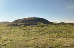
An historic site with a circular hedge following a bank and ditch which marks the boundary of an Iron Age fort between 700 BC and 43 AD. Beneath the site are the remains of a Neolithic camp dated 4000-2000BC which was an enclosure of circles of ditches.

Type:
History

Map Location

URP status: Available (unclaimed)

Claim listing is the best way to manage and protect your URPoint.

Claim URPoint
Sewell Lane, Totternhoe , England

Social Networks