URPoint Details
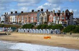
Very old elegant seaside resort which still retains bathing huts.
The River Blyth to the South and Buss Creek to the North form two of the boundaries.
The town has 7 greens, but due to fire in 1659 many of the original houses were destroyed.
Clusters of houses around the greens are a mixture of design, but blend well together.
In 1509 The Common was given to the town which extends into the Town Marshes and down to the River Blyth.
In 1672 the English and French fleets clashed with the Dutch just offshore in Sole Bay. The six 18lb guns standing on the cliff were captured from the Scots at Culloden, and given to the town by the Duke of Cumberland.
The local brewery still produces a wonderful ale and is still delivered by horse and dray.
The Craighurst, on the corner on the Esplanade is very nice and offers beautifully prepared generous servings reasonably priced meals.
Southwold Jack a 15th century man-at-arms carved figure strikes the bell for services to begin in St Edmund's Church which dates from 1460. The 100ft high tower stands watch over the town.
- Type:
- Landmark


