URPoint Details
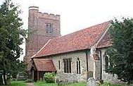
The parish of All Saints is an ancient building sited on a headland overlooking the Lee valley.
The name means headland and meadow.
In the Domesday Book, the common is mentioned as part of the Waltham Hundred, and was disafforested in 1285 for the men of the village to have the rights of pasture. An Act of 1657 gave use of the land to the tenants of 101 ancient houses. This was further regulated in 1778.
The village is five miles long, and is divided into Upper Nazeing, Middle Street and Lower Nazeing.
In Middle Street, at Nazeingbury, ancient crossroads bisect the village, where in 1404, stood the Bury Cross.
The present house of ‘Nazeingbury’ dates back to Tudor times and was in fact the home of Katherine Parr, the sixth wife of Henry VIII.
Legend has it that Boadicea mustered her army for her last battle against the Romans here. Two 18th century obelisks, standing a mile apart, are supposed to mark the spot where she took poison and died.
- Type:
- Landmark


