URPoint Details
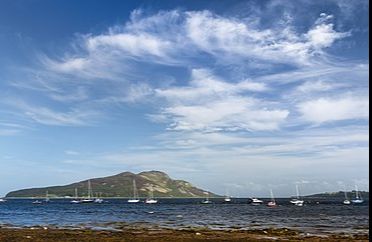
The Holy Isle (Scottish Gaelic: Eilean MoLaise) is one of a number of islands in the United Kingdom which go under the name "Holy Island". It is located in the Firth of Clyde off the west coast inside Lamlash Bay on the larger island of Arran. The island is around 3 kilometres (1.9 mi) long and around 1 kilometre (0.6 mi) wide. Its highest point is the hill Mullach Mòr.
The island has a long history as a sacred site, with a spring or holy well held to have healing properties, the hermit cave of 6th century monk St Molaise, and evidence of a 13th-century monastery. An old Gaelic name for the island was Eilean MoLaise, Molaise's Island; this is the origin (via Elmolaise and Limolas) of "Lamlash", the name of the village on Arran that faces Holy Island.
Some runic writing is to be found on the roof of St Molaise's cave and a Viking fleet sheltered between Arran and Holy Isle before the Battle of Largs.
The island is now owned by the Samyé Ling Buddhist Community, who belong to the Kagyu school of Tibetan Buddhism. The settlements on the island include the Centre for World Peace and Health, founded by Lama Yeshe Losal Rinpoche, on the north of the island. This is an
- Type:
- Landmark


