URPoint Details
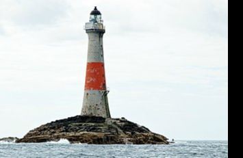
Dubh Artach a remote skerry of basalt rock off the west coast lying 18 miles (29 km) west of Colonsay and 15 miles (24 km) south-west of the Ross of Mull.
A lighthouse designed by Thomas Stevenson with a tower height of 145 feet (44 m) was erected between 1867 and 1872 with a shore station constructed on the Isle of Erraid. The rock is subject to extraordinary sea conditions with waves of 92 feet (28 m) or more being encountered by the keepers. Despite these adverse conditions several men served the light for lengthy periods until it was automated in 1971.
Dubh Artach is the official name of the lighthouse, although the skerry itself is also known as Dhu Heartach. Various interpretations have been provided for the original meaning of the Gaelic name, of which "The Black Rock" is the most likely.
Between 1800 and 1854 thirty ships were wrecked on the reef however, the requirement for a lighthouse was not only to warn seafarers away from Dhu Heartach itself, but also to guide them past the fearsome Torran Rocks, which lie between the Ross of Mull and Colonsay. Originally it was considered to be an impossible site for a light, but the loss of the steamer Bussorah with all
- Type:
- Landmark


