URPoint Details
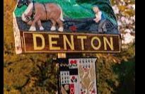
The name meaning ‘the village in the hole’ is derived from the original settlement being sited in a valley round the church. Denton is a rural community and the village sign depicts a horse-drawn plough.
After the great plague of 1665, the villagers moved up the hill to settle around Well Corner with the availability of water the prime consideration.
To the north of the village, a Saxon motte and bailey castle was built which had a track by which the livestock could be driven to safety inside the castle.
The Danes and Vikings made use of the Waveney and Yare and sailed inland to pillage. Nearby are Hangman’s Hill and Misery Corner – grim reminders of the rough justice dealt out in former times.
The flint church of St Mary the Virgin was part Norman and when the round tower collapsed in the 16th century it was replaced by a square one. The beautiful east window in the chancel contains stained glass of many periods, the oldest believed to be 14th century.
- Type:
- Landmark


