URPoint Details
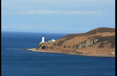
Davaar Island or Island Davaar (Scottish Gaelic: Eilean Dà Bhàrr) is located at the mouth of Campbeltown Loch off the east coast of Kintyre. It is a tidal island, linked to the mainland by a natural shingle causeway called the Dhorlin near Campbeltown at low tide. The crossing can be made in around 40 minutes.
Davaar was known as the island of Sanct Barre between the years 1449 to 1508. The modern form Davaar is from older Do Bharre - thy St Barre. Dr Gillies in his "Place Names of Argyll" appears to accept the popular derivation, Double-pointed (Da-Bharr) Island.
In 1854, a Lighthouse was built on the north of the island by the lighthouse engineers David Davidand Thomas Stevenson. The lighthouse was automated in 1983, and today, Davaar is inhabited by caretakers, sheep, goats and mink.
The Lookout, a square building standing on a small knoll close to the lighthouse, was built during World War Two to house naval crews, whose task it was to stretch anti-submarine nets across the water, protecting Campbeltown. It is now rented out as a holiday home.
The island is also known for its seven caves, one of which contains a life size cave painting depicting the crucifixion, painted
- Type:
- Landmark


