URPoint Details
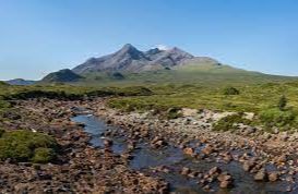
A mountain range with the famous Sgurr nan Gillean rising to 3,167ft is often ascended from Sligachan and is excellent for climbing, the highest is Sgurr Alasdair at 3,251ft.
The Coolins are of interest to geologists and are also noted for the misty conditions which is a danger to inexperienced climbers.
This grand range of mountains is the most precipitous in Great Britain sometimes known as the Black Coolins in order to distinguish them from the much less impressive Red Coolins.
The Red Coolins or Red Hills face the main ridge from the opposite side of Glen Sligachan and their chief peaks of Glamaig at 2,537ft and Marsco at 2,414 are rounded and smooth made of a composite of crumbly pink granite.
Beyond them to the south rises Blaven at 3,042ft a magnificent outlier of the Black Coolins noted for the rock traverse of Clach Glas and overlooking Loch na Creitheach and Loch Slapin both in the Strathaird peninsula.
The main Coolin ridge is essentially for experienced climbers, but it is possible to reach the peak of Bruach na Frithe at 3,143ft.
- Type:
- Landmark


